SIEREM
SIEREM

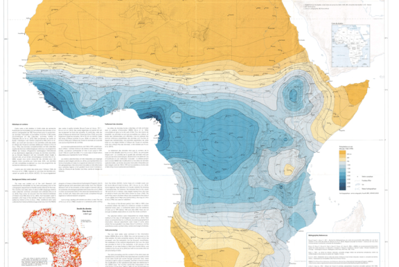
The HydroSciences Montpellier laboratory has developed the Environmental Information System on Water Resources and their Modelling (SIEREM) for the whole of Africa.

It is the most important Environmental Information System on the African continent with 13,000 measuring stations, 33,000 time series, i.e. more than 117 million records, for the period 1837 to 2015.

The hydro-climatological data are coupled with spatialized data: 201 watershed contours, 2962 rivers. The recovery of hydrological archives has enabled SIEREM to be enriched. More than 1342 photos have been collected in 391 geo-referenced albums. The SIEREM site allows free access to all this information except for the raw measurement data which are the property of the African national services.

ADHI
ADHI

This database contains various hydrometric indices, describing runoff characteristics, seasonality, floods and low flows, for about 1500 rivers covering all regions of Africa between 1950 and 2018.

SI OREME
SI OREME

The OSU OREME Information System offers mutualised support in the management of observation data. It takes charge of structuring the data in permanent databases and develops the associated tools. The data can be viewed and accessed on its dedicated portal

OpenFLUID
OpenFLUID

OpenFLUID is a software platform for spatial modelling in landscapes.
Based on an explicit representation of spatial objects and their interactions, OpenFLUID is designed for modelling dynamics at different spatial and temporal scales. It provides an environment for the development and integration of computational codes, model coupling, parameterization and execution of simulations. It is also a collaborative framework for the capitalization and sharing of multi-disciplinary models.
OpenFLUID has already been applied in various contexts: hydrology, diffuse pollution, agricultural practices, erosion, land use planning, etc.
Free, open-source and based on open standards, OpenFLUID is fully commited to open and reproducible science approaches.

CASSIOPEE
CASSIOPEE

The Cassiopée application brings together a set of tools for technicians, engineers, students and researchers in the field of hydraulics for agriculture and the environment. Developed in collaboration with the ecohydraulics R&D cluster, which includes the OFB (French Office for Biodiversity) and the IMFT (Toulouse Institute of Fluid Mechanics) since 2017, Cassiopée centralises calculation modules for :

  • The design of different types of fish passes
  • The design of downstream structures on ichthyocompatible hydroelectric power stations
  • Hydraulic calculations in steady state on canals or rivers
  • Calculations of flow laws on hydraulic structures of various shapes
  • Hydraulic calculations under load
Halle Hydraulique
Halle Hydraulique

The Halle Hydraulique of Montpellier Supagro offers a range of state-of-the-art hydraulic equipment for agriculture and the environment. They are intended for the study of water and pollutant transport phenomena in watercourses and free-surface networks, loaded networks and underground environments. They also enable the development of methods for the management of water resources and aquatic environments.

PRESTI
PRESTI

Combining experiments (controlled and field conditions) and numerical simulations, the PRESTI platform studies the various irrigation systems (gravity, sprinkler, drip), both traditional and innovative. It aims to optimise their technological and agri-environmental performance throughout the water flow.  The platform carries out finalised research work, R&D programmes with industrialists, and tests of equipment under standardised protocols and quality assurance.